|

Outdoor Activities, and Educational
Events in the Pacific Northwest
|

|
Recreation Maps:
Destination Cross Country Ski Area Maps:
The following maps are from
Groomed Cross Country ski areas, Winter Snow Park areas, Tour Skiing, and
Mountaineering ski Traverses. Many of these we make cross country ski trips to
periodically with the club. The effective dates are when the maps were last
updated. Please be aware that some of these areas do expand, will close down, or
can change routings as time progresses.
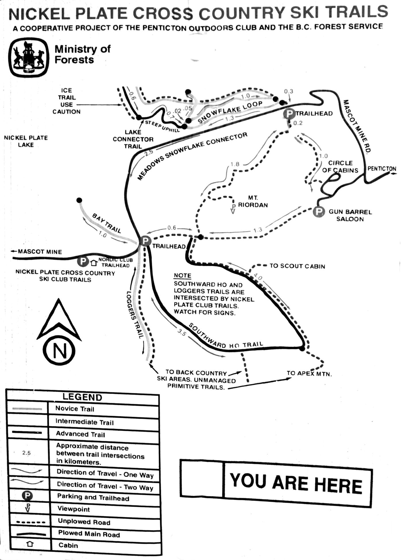
- Nickel Plate Nordic Nordic Ski Map:
Nickel Plate is six kilometers past the Apex Alpine downhill ski
area which is West of Penticton BC Canada. This is a high altitude
groomed cross country ski area maintained by a well organized ski
club. They do charge trail fees. Date: 2007
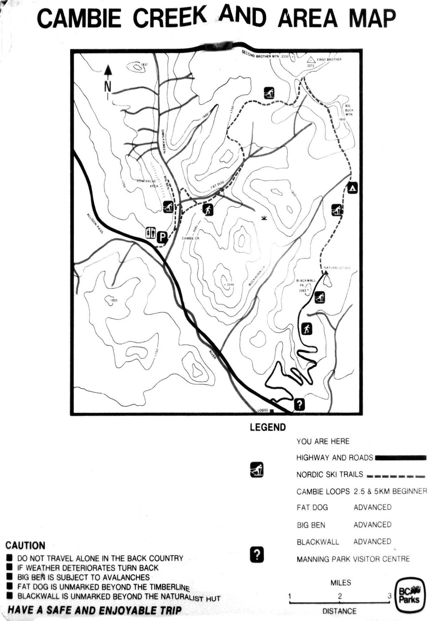
- Cambie Creek Cross Country Ski Map:
Cambie Creek is half way between Apex Alpine downhill ski area and
Nickel Plate Nordic, and West of Penticton BC Canada. Drive to Apex
Alpine from town, at ski area stay right and continue three more kilometers
to the small plowed pullouts on the side of the road. There is not
much signage here so take a copy of the map with you. No trail fees
are charged here. Date:2007
-
-
Local ski & Snowshoe Maps:
The following maps are from the local Cascade Mountains, and are relatively easy to get to with relyable snow, most years.
- Cabin Creek Sno-Park: This is a very popular snow park for nordic skiing and snowshoing in Snoqualmie Pass.
- Chiwawa Sno-Park: This
Lake Wenatchee area snow park has a nice 4mi. ski loop and is almost
always deserted. Combine with another tour in the area like north
Wenatchee for a nice day of east of the mountains skiing or snowshoeing.
- Crystal Springs Sno-Park:
Crystal Springs also in Snoqualmie Pass is a large parking area with
lots going on but good separation of access trails for skiers,
snowshoers, sled dog teams, and snowmobiles. There are lots of options
here including access to the Iron Horse trail.
- Lake Wenatchee Sno-Park:
Lake Wenatchee is a bit of a drive from the Puget Sound basin but
ofters a good variety of trails and usually dryer weather.
- Plain Valley Nordic Center:
This is a full service nordic center with rentals lessons and more,
located in the Lake Wenatchee basin. The trails are generally quite
gentil and scenic.
- Snoqualmie Summit Nordic Ski Center:
This nordic center also offers rentals and lessons and has a nice large
trail system for intermediate and advanced skiers. The system is
accessible from a chairlift ride to the top of the plateau, the ride up
and back down are included in your trail pass fee.
- Stevens Nordic Center:
About five miles east of Stevens pass is a trail network with a nice
variety of beginner to advanced trails. They also have lessons,
rentals, and food service, and a biathalon range where you might catch
a competition on weekends.
Lowland Park Walking-Trail Maps:
These are catagorized by region north, south, east, and central to
the Seattle Lowlands and include some of the more beautiful forested
trails we have in lowland parks. The trails range from shorter half
mile walks to three to five miles in lengh. See trail description and
driving directions on the maps.
Washington
Getaways, Recreation and Activities http://www.kcls.org/wood/woodrec.html
Home | Contact
| Photo Gallery |
Links | Environment |
Events | Adventures